


zap Blanzey

ISAGIL
User
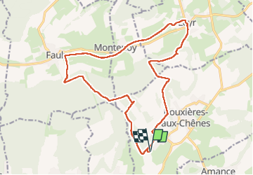

Length
19.3 km

Max alt
413 m

Uphill gradient
398 m
Km-Effort
25 km

Min alt
233 m

Downhill gradient
398 m
Boucle
Yes
Creation date :
2024-09-12 06:34:17.789
Updated on :
2024-09-12 12:20:04.65
4h44
Difficulty : Very difficult

FREE GPS app for hiking
 SityTrail
IGN / Geographical institutes
SityTrail Plus
The world is yours!
About
Trail Walking of 19.3 km to be discovered at Grand Est, Meurthe-et-Moselle, Bouxières-aux-Chênes. This trail is proposed by ISAGIL.
Description
chapelle
Positioning
Country:
France
Region :
Grand Est
Department/Province :
Meurthe-et-Moselle
Municipality :
Bouxières-aux-Chênes
Location:
Unknown
Start:(Dec)
Start:(UTM)
297617 ; 5404526 (32U) N.
Comments