


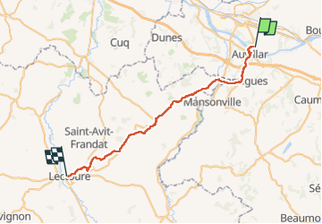
Compostelle Espalais a Lectoure

Nono55
User

Length
45 km

Max alt
214 m

Uphill gradient
824 m
Km-Effort
55 km

Min alt
56 m

Downhill gradient
702 m
Boucle
No
Creation date :
2024-09-12 05:55:13.0
Updated on :
2024-09-12 19:36:49.866
8h20
Difficulty : Medium

FREE GPS app for hiking
 SityTrail
IGN / Geographical institutes
SityTrail Plus
The world is yours!
About
Trail Walking of 45 km to be discovered at Occitania, Tarn-et-Garonne, Espalais. This trail is proposed by Nono55.
Description
Chemin vallonné au départ et la fin beaucoup de route arrivé à Lectoure très jolie village
Positioning
Country:
France
Region :
Occitania
Department/Province :
Tarn-et-Garonne
Municipality :
Espalais
Location:
Unknown
Start:(Dec)
Start:(UTM)
332386 ; 4882588 (31T) N.
Comments