Moustier

jean52
User

Length
9.7 km

Max alt
986 m

Uphill gradient
293 m
Km-Effort
14.1 km

Min alt
637 m

Downhill gradient
445 m
Boucle
No
Creation date :
2024-09-13 07:56:45.0
Updated on :
2024-09-13 12:11:56.069
2h53
Difficulty : Difficult

FREE GPS app for hiking
 SityTrail
IGN / Geographical institutes
SityTrail Plus
The world is yours!
About
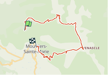
Trail Walking of 9.7 km to be discovered at Provence-Alpes-Côte d'Azur, Alpes-de-Haute-Provence, Moustiers-Sainte-Marie. This trail is proposed by jean52.
Photos

Positioning
Country:
France
Region :
Provence-Alpes-Côte d'Azur
Department/Province :
Alpes-de-Haute-Provence
Municipality :
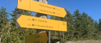
Moustiers-Sainte-Marie
Location:
Unknown
Start:(Dec)
Start:(UTM)
276169 ; 4859388 (32T) N.
Comments