


Compostelle Lectoure a Castelnau sur l Auviovion

Nono55
User
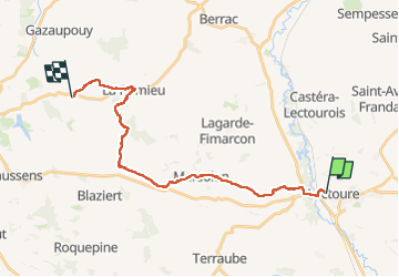

Length
27 km

Max alt
220 m

Uphill gradient
443 m
Km-Effort
33 km

Min alt
77 m

Downhill gradient
467 m
Boucle
No
Creation date :
2024-09-13 05:40:15.0
Updated on :
2024-09-13 13:36:57.262
4h58
Difficulty : Medium

FREE GPS app for hiking
 SityTrail
IGN / Geographical institutes
SityTrail Plus
The world is yours!
About
Trail Walking of 27 km to be discovered at Occitania, Gers, Lectoure. This trail is proposed by Nono55.
Description
Petite étape 23 km vallonné quelques montée sèches .Village de Lectoure et Romieu magnifique arrêt au gîte L encre tenue pas des jeunes sympa
Positioning
Country:
France
Region :
Occitania
Department/Province :
Gers
Municipality :
Lectoure
Location:
Unknown
Start:(Dec)
Start:(UTM)
308771 ; 4867445 (31T) N.
Comments