


prieuré d'Yron

RC76
User

Length
2.2 km

Max alt
105 m

Uphill gradient
15 m
Km-Effort
2.4 km

Min alt
94 m

Downhill gradient
12 m
Boucle
No
Creation date :
2024-09-14 07:00:27.583
Updated on :
2024-09-14 07:39:48.466
38m
Difficulty : Easy

FREE GPS app for hiking
 SityTrail
IGN / Geographical institutes
SityTrail Plus
The world is yours!
About
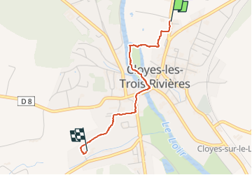
Trail Walking of 2.2 km to be discovered at Centre-Loire Valley, Eure-et-Loir, Cloyes-les-Trois-Rivières. This trail is proposed by RC76.
Positioning
Country:
France
Region :
Centre-Loire Valley
Department/Province :
Eure-et-Loir
Municipality :
Cloyes-les-Trois-Rivières
Location:
Cloyes-sur-le-Loir
Start:(Dec)
Start:(UTM)
368435 ; 5318005 (31U) N.
Comments