Ermenonville Mer de Sable_Stèle DC10_Trace GPS simplifiée_9,4km

Pousscailleux
User
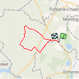

Length
9.2 km

Max alt
119 m

Uphill gradient
98 m
Km-Effort
10.5 km

Min alt
72 m

Downhill gradient
98 m
Boucle
Yes
Creation date :
2015-05-11 00:00:00.0
Updated on :
2015-05-11 00:00:00.0
2h21
Difficulty : Easy

FREE GPS app for hiking
 SityTrail
IGN / Geographical institutes
SityTrail Plus
The world is yours!
About
Trail Walking of 9.2 km to be discovered at Hauts-de-France, Oise, Fontaine-Chaalis. This trail is proposed by Pousscailleux.
Description
Départ du parking de la Mer de Sable.
Positioning
Country:
France
Region :
Hauts-de-France
Department/Province :
Oise
Municipality :
Fontaine-Chaalis
Location:
Unknown
Start:(Dec)
Start:(UTM)
476465 ; 5443837 (31U) N.
Comments