


Jouy en Josas repérage du 6/10/24

mouchette94
User
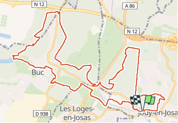

Length
16.2 km

Max alt
184 m

Uphill gradient
302 m
Km-Effort
20 km

Min alt
87 m

Downhill gradient
301 m
Boucle
Yes
Creation date :
2024-09-15 06:44:29.0
Updated on :
2024-09-15 12:55:40.791
4h21
Difficulty : Easy

FREE GPS app for hiking
 SityTrail
IGN / Geographical institutes
SityTrail Plus
The world is yours!
About
Trail Walking of 16.2 km to be discovered at Ile-de-France, Yvelines, Jouy-en-Josas. This trail is proposed by mouchette94.
Positioning
Country:
France
Region :
Ile-de-France
Department/Province :
Yvelines
Municipality :
Jouy-en-Josas
Location:
Unknown
Start:(Dec)
Start:(UTM)
438466 ; 5401678 (31U) N.
Comments