


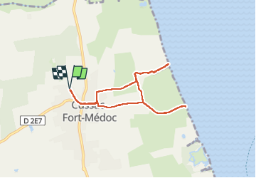
estuaire en partant de cussac fort médoc

gnortier
User

Length
7.4 km

Max alt
17 m

Uphill gradient
27 m
Km-Effort
7.8 km

Min alt
0 m

Downhill gradient
27 m
Boucle
Yes
Creation date :
2024-09-15 13:45:29.093
Updated on :
2024-09-15 16:12:44.271
2h17
Difficulty : Very easy

FREE GPS app for hiking
 SityTrail
IGN / Geographical institutes
SityTrail Plus
The world is yours!
About
Trail Walking of 7.4 km to be discovered at New Aquitaine, Gironde, Cussac-Fort-Médoc. This trail is proposed by gnortier.
Photos


Positioning
Country:
France
Region :
New Aquitaine
Department/Province :
Gironde
Municipality :
Cussac-Fort-Médoc
Location:
Unknown
Start:(Dec)
Start:(UTM)
678247 ; 4999099 (30T) N.
Comments