


Videlles-Courances_1263530_12km

gdela
User
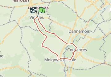

Length
11.8 km

Max alt
144 m

Uphill gradient
192 m
Km-Effort
14.3 km

Min alt
58 m

Downhill gradient
192 m
Boucle
Yes
Creation date :
2024-09-15 16:30:10.66
Updated on :
2024-09-15 16:34:29.474
3h15
Difficulty : Difficult

FREE GPS app for hiking
 SityTrail
IGN / Geographical institutes
SityTrail Plus
The world is yours!
About
Trail Walking of 11.8 km to be discovered at Ile-de-France, Essonne, Videlles. This trail is proposed by gdela.
Positioning
Country:
France
Region :
Ile-de-France
Department/Province :
Essonne
Municipality :
Videlles
Location:
Unknown
Start:(Dec)
Start:(UTM)
457986 ; 5368050 (31U) N.
Comments