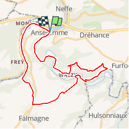
Anseremme - Walzin - Freyr - Anseremme

ameurant
User

Length
17.6 km

Max alt
220 m

Uphill gradient
380 m
Km-Effort
23 km

Min alt
90 m

Downhill gradient
382 m
Boucle
Yes
Creation date :
2014-12-10 00:00:00.0
Updated on :
2014-12-10 00:00:00.0
4h02
Difficulty : Medium

FREE GPS app for hiking
 SityTrail
IGN / Geographical institutes
SityTrail Plus
The world is yours!
About
Trail Walking of 17.6 km to be discovered at Wallonia, Namur, Dinant. This trail is proposed by ameurant.
Description
Remonter la Lesse de Anseremme à Walzin.
Traverser la Lesse.
Remonter sur Famioulg.
Descendre sur la Meuse
Longer le pied des rochers de Freyr
Retour à Anseremme par le bord de Meuse.
Positioning
Country:
Belgium
Region :
Wallonia
Department/Province :
Namur
Municipality :
Dinant
Location:
Anseremme
Start:(Dec)
Start:(UTM)
636086 ; 5566819 (31U) N.
Comments