


Ain et voie bleue

janussity
User
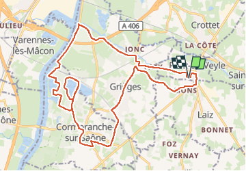

Length
24 km

Max alt
213 m

Uphill gradient
164 m
Km-Effort
26 km

Min alt
158 m

Downhill gradient
164 m
Boucle
Yes
Creation date :
2024-09-17 14:36:24.159
Updated on :
2024-09-17 16:26:21.642
1h43
Difficulty : Medium

FREE GPS app for hiking
 SityTrail
IGN / Geographical institutes
SityTrail Plus
The world is yours!
About
Trail Mountain bike of 24 km to be discovered at Auvergne-Rhône-Alpes, Ain, Pont-de-Veyle. This trail is proposed by janussity.
Description
VTT par vent du nord avec soleil
Positioning
Country:
France
Region :
Auvergne-Rhône-Alpes
Department/Province :
Ain
Municipality :
Pont-de-Veyle
Location:
Unknown
Start:(Dec)
Start:(UTM)
645208 ; 5124562 (31T) N.
Comments