


2024 09 Oncy t1

michel1025
User
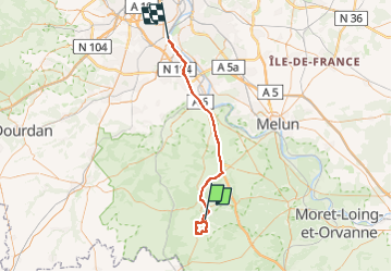

Length
53 km

Max alt
123 m

Uphill gradient
420 m
Km-Effort
59 km

Min alt
31 m

Downhill gradient
452 m
Boucle
No
Creation date :
2024-09-17 12:04:49.0
Updated on :
2024-09-18 06:33:44.193
2h31
Difficulty : Difficult

FREE GPS app for hiking
 SityTrail
IGN / Geographical institutes
SityTrail Plus
The world is yours!
About
Trail Walking of 53 km to be discovered at Ile-de-France, Essonne, Oncy-sur-École. This trail is proposed by michel1025.
Positioning
Country:
France
Region :
Ile-de-France
Department/Province :
Essonne
Municipality :
Oncy-sur-École
Location:
Unknown
Start:(Dec)
Start:(UTM)
461126 ; 5358783 (31U) N.
Comments