


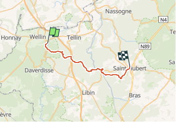
Halma - Saint-Hubert (27km)

xtislair
User

Length
26 km

Max alt
461 m

Uphill gradient
719 m
Km-Effort
35 km

Min alt
198 m

Downhill gradient
498 m
Boucle
No
Creation date :
2024-09-18 13:52:31.836
Updated on :
2024-09-18 13:54:43.992
7h58
Difficulty : Very difficult

FREE GPS app for hiking
 SityTrail
IGN / Geographical institutes
SityTrail Plus
The world is yours!
About
Trail Walking of 26 km to be discovered at Wallonia, Luxembourg, Wellin. This trail is proposed by xtislair.
Description
Prendre Bus 162b de Saint-Hubert jusque Grupont Centre
Puis le 29 jusque Halma
Positioning
Country:
Belgium
Region :
Wallonia
Department/Province :
Luxembourg
Municipality :
Wellin
Location:
Unknown
Start:(Dec)
Start:(UTM)
653343 ; 5548684 (31U) N.
Comments