


zap sept 2024 moyen

ISAGIL
User
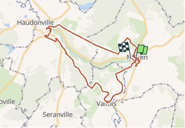

Length
19.7 km

Max alt
324 m

Uphill gradient
333 m
Km-Effort
24 km

Min alt
230 m

Downhill gradient
333 m
Boucle
No
Creation date :
2024-09-19 07:02:17.355
Updated on :
2024-09-19 14:52:14.377
7h25
Difficulty : Very difficult

FREE GPS app for hiking
 SityTrail
IGN / Geographical institutes
SityTrail Plus
The world is yours!
About
Trail Walking of 19.7 km to be discovered at Grand Est, Meurthe-et-Moselle, Moyen. This trail is proposed by ISAGIL.
Description
moyen
Positioning
Country:
France
Region :
Grand Est
Department/Province :
Meurthe-et-Moselle
Municipality :
Moyen
Location:
Unknown
Start:(Dec)
Start:(UTM)
320327 ; 5372747 (32U) N.
Comments