


lac luitel - belvédére du col de la madeleine

maupassant38
User
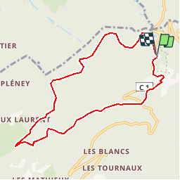

Length
9.1 km

Max alt
1415 m

Uphill gradient
435 m
Km-Effort
14.9 km

Min alt
1095 m

Downhill gradient
440 m
Boucle
Yes
Creation date :
2019-02-22 22:31:39.124
Updated on :
2019-02-22 22:31:39.129
3h17
Difficulty : Medium

FREE GPS app for hiking
 SityTrail
IGN / Geographical institutes
SityTrail Plus
The world is yours!
About
Trail Walking of 9.1 km to be discovered at Auvergne-Rhône-Alpes, Isère, Séchilienne. This trail is proposed by maupassant38.
Positioning
Country:
France
Region :
Auvergne-Rhône-Alpes
Department/Province :
Isère
Municipality :
Séchilienne
Location:
Unknown
Start:(Dec)
Start:(UTM)
724179 ; 4996597 (31T) N.
Comments