


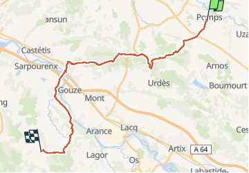
Compostelle Pomps Savelade

Nono55
User

Length
33 km

Max alt
229 m

Uphill gradient
470 m
Km-Effort
39 km

Min alt
72 m

Downhill gradient
489 m
Boucle
No
Creation date :
2024-09-19 05:37:30.0
Updated on :
2024-09-19 17:18:31.806
6h22
Difficulty : Medium

FREE GPS app for hiking
 SityTrail
IGN / Geographical institutes
SityTrail Plus
The world is yours!
About
Trail Walking of 33 km to be discovered at New Aquitaine, Pyrénées-Atlantiques, Pomps. This trail is proposed by Nono55.
Description
Parcours sympa au départ puis route sur la fin avant Sauvelade quelques belles montées Arrive à Sauvelade très bien
Positioning
Country:
France
Region :
New Aquitaine
Department/Province :
Pyrénées-Atlantiques
Municipality :
Pomps
Location:
Unknown
Start:(Dec)
Start:(UTM)
698662 ; 4818172 (30T) N.
Comments