


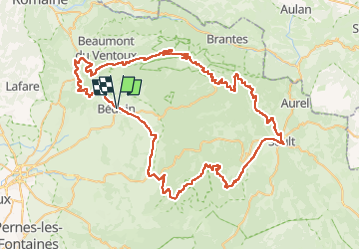
Le Ventoux par Sault Malaucène 100km

thonyc
User GUIDE

Length
100 km

Max alt
1902 m

Uphill gradient
2380 m
Km-Effort
132 km

Min alt
278 m

Downhill gradient
2383 m
Boucle
Yes
Creation date :
2024-09-20 06:00:15.448
Updated on :
2024-09-28 06:30:50.878
7h58
Difficulty : Very difficult

FREE GPS app for hiking
 SityTrail
IGN / Geographical institutes
SityTrail Plus
The world is yours!
About
Trail Road bike of 100 km to be discovered at Provence-Alpes-Côte d'Azur, Vaucluse, Bédoin. This trail is proposed by thonyc.
Positioning
Country:
France
Region :
Provence-Alpes-Côte d'Azur
Department/Province :
Vaucluse
Municipality :
Bédoin
Location:
Unknown
Start:(Dec)
Start:(UTM)
674711 ; 4888032 (31T) N.
Comments