


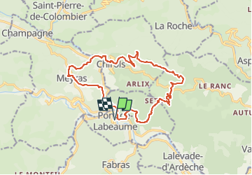
Pt labeaume Chirols Meyras 17km

thonyc
User GUIDE

Length
17.3 km

Max alt
843 m

Uphill gradient
738 m
Km-Effort
27 km

Min alt
295 m

Downhill gradient
738 m
Boucle
Yes
Creation date :
2024-09-20 08:53:01.378
Updated on :
2024-09-20 08:53:32.977
6h09
Difficulty : Very difficult

FREE GPS app for hiking
 SityTrail
IGN / Geographical institutes
SityTrail Plus
The world is yours!
About
Trail Walking of 17.3 km to be discovered at Auvergne-Rhône-Alpes, Ardèche, Pont-de-Labeaume. This trail is proposed by thonyc.
Positioning
Country:
France
Region :
Auvergne-Rhône-Alpes
Department/Province :
Ardèche
Municipality :
Pont-de-Labeaume
Location:
Unknown
Start:(Dec)
Start:(UTM)
602225 ; 4946599 (31T) N.
Comments