


Compostelle Sauvelade a Aroue

Nono55
User
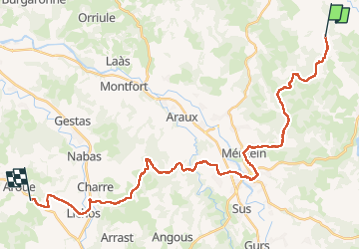

Length
38 km

Max alt
265 m

Uphill gradient
623 m
Km-Effort
46 km

Min alt
97 m

Downhill gradient
629 m
Boucle
No
Creation date :
2024-09-20 05:49:02.0
Updated on :
2024-09-20 15:56:33.743
7h28
Difficulty : Medium

FREE GPS app for hiking
 SityTrail
IGN / Geographical institutes
SityTrail Plus
The world is yours!
About
Trail Walking of 38 km to be discovered at New Aquitaine, Pyrénées-Atlantiques, Sauvelade. This trail is proposed by Nono55.
Description
Beau paysage basque mais trop de route
Positioning
Country:
France
Region :
New Aquitaine
Department/Province :
Pyrénées-Atlantiques
Municipality :
Sauvelade
Location:
Unknown
Start:(Dec)
Start:(UTM)
685647 ; 4807076 (30T) N.
Comments