


21.09.24 - Aubure

delm
User
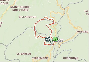

Length
10.5 km

Max alt
1136 m

Uphill gradient
430 m
Km-Effort
16.2 km

Min alt
819 m

Downhill gradient
423 m
Boucle
Yes
Creation date :
2024-09-21 09:20:02.0
Updated on :
2024-09-21 13:34:16.586

FREE GPS app for hiking
 SityTrail
IGN / Geographical institutes
SityTrail Plus
The world is yours!
About
Trail of 10.5 km to be discovered at Grand Est, Haut-Rhin, Fréland. This trail is proposed by delm.
Positioning
Country:
France
Region :
Grand Est
Department/Province :
Haut-Rhin
Municipality :
Fréland
Location:
Unknown
Start:(Dec)
Start:(UTM)
367223 ; 5339339 (32U) N.
Comments