


Sob 12 selles sur cher valençay

Glurps
User
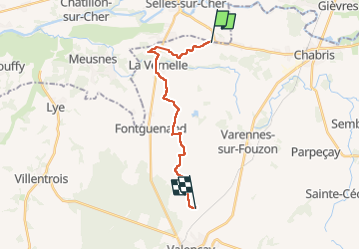

Length
15.8 km

Max alt
130 m

Uphill gradient
123 m
Km-Effort
17.3 km

Min alt
74 m

Downhill gradient
84 m
Boucle
No
Creation date :
2024-09-21 07:17:26.0
Updated on :
2024-09-21 15:31:36.117

FREE GPS app for hiking
 SityTrail
IGN / Geographical institutes
SityTrail Plus
The world is yours!
About
Trail of 15.8 km to be discovered at Centre-Loire Valley, Loir-et-Cher, Selles-sur-Cher. This trail is proposed by Glurps.
Positioning
Country:
France
Region :
Centre-Loire Valley
Department/Province :
Loir-et-Cher
Municipality :
Selles-sur-Cher
Location:
Unknown
Start:(Dec)
Start:(UTM)
392619 ; 5234890 (31T) N.
Comments