Trail Walking Arvière-en-Valromey - Le Col du Grand Colombier - Photo
© OpenStreetMap contributors
Length
Length
15.9 km
Max alt
Max alt
1512 m
Uphill gradient
Uphill gradient
718 m
Km-Effort
Km-Effort  
25 km
Min alt
Min alt
1150 m
Downhill gradient
Downhill gradient
720 m
Boucle
Boucle
Yes
Creation date :
2015-08-03 00:00:00.0
Updated on :
2015-08-03 00:00:00.0

(0 Reviews)

Walking
Walking
5h29
Difficulty : Medium

Scan this QR Code to open this trail in the SityTrail application

FREE GPS app for hiking

Logo SityTrail SityTrail

IGN / Geographical institutes

Download SityTrail from the App Store Download SityTrail from Google Play

Logo SityTrail SityTrail Plus

The world is yours!

Download SityTrail from the App Store Download SityTrail from Google Play Download SityTrail on Huawei AppGallery

About

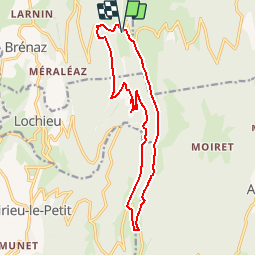
Trail Walking of 15.9 km to be discovered at Auvergne-Rhône-Alpes, Ain, Arvière-en-Valromey. This trail is proposed by bourel.jacques.

Description

Départ du parking de la  Grange d'en bas.
Passage par la Crête de l'Hergues et les ruines de l'ancienne chartreuse d'Arvière.
Rando à faire par temps très clair (superbe point de vue sur le massif du Mont Blanc) si possible vers le 15 mai au moment de la floraison des jonquilles.

Elevation profile

Positioning

Country:
France
Region :
Auvergne-Rhône-Alpes
Department/Province :
Ain
Municipality :
Arvière-en-Valromey
Location:
Brénaz
Start:(UTM)
713619 ; 5092304 (31T) N.


Close
My subscriptions