


TJG-A52S-Rando-nocturne

Jack-94
User
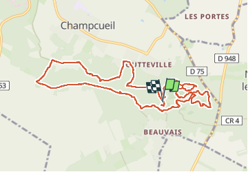

Length
11.4 km

Max alt
153 m

Uphill gradient
214 m
Km-Effort
14.3 km

Min alt
86 m

Downhill gradient
207 m
Boucle
Yes
Creation date :
2024-09-21 16:03:09.19
Updated on :
2024-09-22 13:26:47.169
6h06
Difficulty : Difficult

FREE GPS app for hiking
 SityTrail
IGN / Geographical institutes
SityTrail Plus
The world is yours!
About
Trail Walking of 11.4 km to be discovered at Ile-de-France, Essonne, Champcueil. This trail is proposed by Jack-94.

Positioning
Country:
France
Region :
Ile-de-France
Department/Province :
Essonne
Municipality :
Champcueil
Location:
Unknown
Start:(Dec)
Start:(UTM)
460761 ; 5372272 (31U) N.
Comments