


Vinay Beaulieu -Plateau de la Blache et plaine

crocau
User
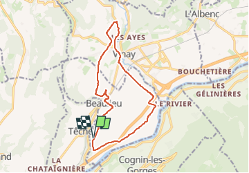

Length
14.3 km

Max alt
364 m

Uphill gradient
174 m
Km-Effort
16.6 km

Min alt
225 m

Downhill gradient
174 m
Boucle
Yes
Creation date :
2024-09-22 15:02:06.865
Updated on :
2024-10-29 21:01:41.189
1h09
Difficulty : Very easy

FREE GPS app for hiking
 SityTrail
IGN / Geographical institutes
SityTrail Plus
The world is yours!
About
Trail Mountain bike of 14.3 km to be discovered at Auvergne-Rhône-Alpes, Isère, Beaulieu. This trail is proposed by crocau.
Photos


Positioning
Country:
France
Region :
Auvergne-Rhône-Alpes
Department/Province :
Isère
Municipality :
Beaulieu
Location:
Unknown
Start:(Dec)
Start:(UTM)
687528 ; 5005744 (31T) N.
Comments