


la borde de Gabriel

c.chehere
User
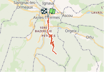

Length
13.2 km

Max alt
1440 m

Uphill gradient
716 m
Km-Effort
23 km

Min alt
728 m

Downhill gradient
716 m
Boucle
Yes
Creation date :
2024-09-23 05:23:23.544
Updated on :
2024-09-23 11:41:07.491
4h32
Difficulty : Medium

FREE GPS app for hiking
 SityTrail
IGN / Geographical institutes
SityTrail Plus
The world is yours!
About
Trail Walking of 13.2 km to be discovered at Occitania, Ariège, Ax-les-Thermes. This trail is proposed by c.chehere.
Photos


Positioning
Country:
France
Region :
Occitania
Department/Province :
Ariège
Municipality :
Ax-les-Thermes
Location:
Unknown
Start:(Dec)
Start:(UTM)
405015 ; 4730239 (31T) N.
Comments