


rando sous la pluie 11km

jeanmarcMasson
User GUIDE
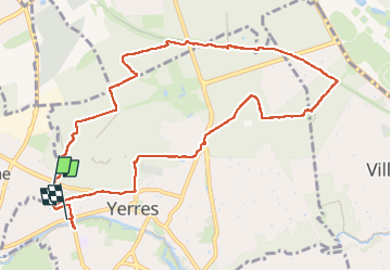

Length
10.6 km

Max alt
119 m

Uphill gradient
89 m
Km-Effort
12 km

Min alt
35 m

Downhill gradient
141 m
Boucle
No
Creation date :
2024-09-25 07:23:11.683
Updated on :
2024-09-25 09:57:59.138
2h10
Difficulty : Medium

FREE GPS app for hiking
 SityTrail
IGN / Geographical institutes
SityTrail Plus
The world is yours!
About
Trail Walking of 10.6 km to be discovered at Ile-de-France, Essonne, Crosne. This trail is proposed by jeanmarcMasson.
Positioning
Country:
France
Region :
Ile-de-France
Department/Province :
Essonne
Municipality :
Crosne
Location:
Unknown
Start:(Dec)
Start:(UTM)
461422 ; 5396307 (31U) N.
Comments