


fillieres 26.09.2024

jcb48
User
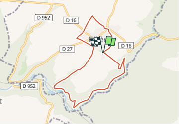

Length
7.8 km

Max alt
366 m

Uphill gradient
129 m
Km-Effort
9.5 km

Min alt
281 m

Downhill gradient
129 m
Boucle
Yes
Creation date :
2024-09-25 14:30:11.163
Updated on :
2024-09-25 14:31:59.039
2h09
Difficulty : Easy
2h09
Difficulty : Medium

FREE GPS app for hiking
 SityTrail
IGN / Geographical institutes
SityTrail Plus
The world is yours!
About
Trail On foot of 7.8 km to be discovered at Grand Est, Meurthe-et-Moselle, Fillières. This trail is proposed by jcb48.
Description
randonnée
Positioning
Country:
France
Region :
Grand Est
Department/Province :
Meurthe-et-Moselle
Municipality :
Fillières
Location:
Unknown
Start:(Dec)
Start:(UTM)
706398 ; 5475924 (31U) N.
Comments