


méandres de Queuille

Gegetop
User

Length
12.6 km

Max alt
759 m

Uphill gradient
377 m
Km-Effort
17.6 km

Min alt
470 m

Downhill gradient
379 m
Boucle
Yes
Creation date :
2015-05-13 00:00:00.0
Updated on :
2015-05-13 00:00:00.0
3h14
Difficulty : Medium

FREE GPS app for hiking
 SityTrail
IGN / Geographical institutes
SityTrail Plus
The world is yours!
About
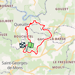
Trail Walking of 12.6 km to be discovered at Auvergne-Rhône-Alpes, Puy-de-Dôme, Saint-Georges-de-Mons. This trail is proposed by Gegetop.
Description
Très agréable à faire au printemps par une chaude journée de mai par exemple car beaucoup de forêts, mais dénivelé assez raide.


Positioning
Country:
France
Region :
Auvergne-Rhône-Alpes
Department/Province :
Puy-de-Dôme
Municipality :
Saint-Georges-de-Mons
Location:
Unknown
Start:(Dec)
Start:(UTM)
488748 ; 5088502 (31T) N.
Comments