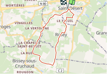
Trail Walking Saint-Désert - Sources du Reuil - Photo
© OpenStreetMap contributors
Length
Length
7.6 km
Max alt
Max alt
344 m
Uphill gradient
Uphill gradient
168 m
Km-Effort
Km-Effort  
9.8 km
Min alt
Min alt
230 m
Downhill gradient
Downhill gradient
168 m
Boucle
Boucle
Yes
Creation date :
2024-09-26 09:59:36.742
Updated on :
2024-12-11 09:35:37.803

(0 Reviews)

Walking
Walking
2h13
Difficulty : Medium

Scan this QR Code to open this trail in the SityTrail application

FREE GPS app for hiking

Logo SityTrail SityTrail

IGN / Geographical institutes

Download SityTrail from the App Store Download SityTrail from Google Play

Logo SityTrail SityTrail Plus

The world is yours!

Download SityTrail from the App Store Download SityTrail from Google Play Download SityTrail on Huawei AppGallery

About

Trail Walking of 7.6 km to be discovered at Bourgogne-Franche-Comté, Saône-et-Loire, Saint-Désert. This trail is proposed by jacques71710.

Elevation profile

Points of interest

Point of interest Saint-Désert - Saint-Désert : Parking de l'Église - Photo
jacques71710
Point of interest Rosey - Église de Rosey - Photo
jacques71710
Point of interest Rosey - Monument aux Morts à Rosey - Photo
jacques71710
Point of interest Bissey-sous-Cruchaud - Croisement des Vignes - Photo
jacques71710
BISSEY-SOUS-CRUCHAUD 
Point of interest Bissey-sous-Cruchaud - Croisement des
jacques71710
BISSEY-SOUS-CRUCHAUD 
Point of interest Bissey-sous-Cruchaud - Croisement en X - Photo
jacques71710
BISSEY-SOUS-CRUCHAUD 
Point of interest Moroges - Croisement Route de Rosey - Photo
jacques71710
Point of interest Saint-Désert - Chemin du Moulin à Vent - Photo
jacques71710
Point of interest Saint-Désert - Saint-Désert : Parking de l'Église - Photo
jacques71710

Positioning

Country:
France
Region :
Bourgogne-Franche-Comté
Department/Province :
Saône-et-Loire
Municipality :
Saint-Désert
Location:
Unknown
Start:(UTM)
630568 ; 5179237 (31T) N.


Close
My subscriptions