


TOG-A52s-Forêt de Carnelle

Jack-94
User
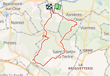

Length
16.7 km

Max alt
218 m

Uphill gradient
391 m
Km-Effort
22 km

Min alt
57 m

Downhill gradient
391 m
Boucle
Yes
Creation date :
2024-09-28 07:37:32.419
Updated on :
2024-09-29 20:33:19.498
7h15
Difficulty : Very difficult

FREE GPS app for hiking
 SityTrail
IGN / Geographical institutes
SityTrail Plus
The world is yours!
About
Trail Walking of 16.7 km to be discovered at Ile-de-France, Val-d'Oise, Noisy-sur-Oise. This trail is proposed by Jack-94.
Positioning
Country:
France
Region :
Ile-de-France
Department/Province :
Val-d'Oise
Municipality :
Noisy-sur-Oise
Location:
Unknown
Start:(Dec)
Start:(UTM)
451197 ; 5442854 (31U) N.
Comments