le martrat

patourad
User

Length
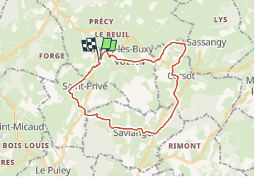
14.5 km

Max alt
381 m

Uphill gradient
348 m
Km-Effort
19.1 km

Min alt
256 m

Downhill gradient
348 m
Boucle
Yes
Creation date :
2024-10-01 06:51:15.584
Updated on :
2024-10-01 06:51:58.743
4h20
Difficulty : Very difficult

FREE GPS app for hiking
 SityTrail
IGN / Geographical institutes
SityTrail Plus
The world is yours!
About
Trail Walking of 14.5 km to be discovered at Bourgogne-Franche-Comté, Saône-et-Loire, Marcilly-lès-Buxy. This trail is proposed by patourad.
Positioning
Country:
France
Region :
Bourgogne-Franche-Comté
Department/Province :
Saône-et-Loire
Municipality :
Marcilly-lès-Buxy
Location:
Unknown
Start:(Dec)
Start:(UTM)
621321 ; 5174675 (31T) N.
Comments