


rond fontaine

jcb48
User
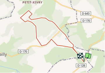

Length
8.3 km

Max alt
311 m

Uphill gradient
124 m
Km-Effort
9.9 km

Min alt
269 m

Downhill gradient
123 m
Boucle
Yes
Creation date :
2024-10-02 07:06:18.003
Updated on :
2024-10-02 07:06:54.964
2h15
Difficulty : Easy

FREE GPS app for hiking
 SityTrail
IGN / Geographical institutes
SityTrail Plus
The world is yours!
About
Trail On foot of 8.3 km to be discovered at Grand Est, Meuse, Saint-Laurent-sur-Othain. This trail is proposed by jcb48.
Description
marche
Positioning
Country:
France
Region :
Grand Est
Department/Province :
Meuse
Municipality :
Saint-Laurent-sur-Othain
Location:
Unknown
Start:(Dec)
Start:(UTM)
686186 ; 5477079 (31U) N.
Comments