


20100725090747

popo
User
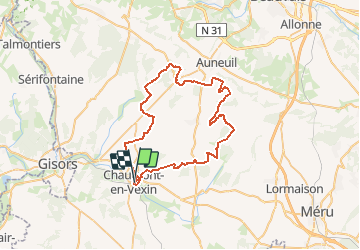

Length
53 km

Max alt
240 m

Uphill gradient
647 m
Km-Effort
61 km

Min alt
61 m

Downhill gradient
649 m
Boucle
Yes
Creation date :
2014-12-10 00:00:00.0
Updated on :
2014-12-10 00:00:00.0
--
Difficulty : Unknown

FREE GPS app for hiking
 SityTrail
IGN / Geographical institutes
SityTrail Plus
The world is yours!
About
Trail Other activity of 53 km to be discovered at Hauts-de-France, Oise, Chaumont-en-Vexin. This trail is proposed by popo.
Positioning
Country:
France
Region :
Hauts-de-France
Department/Province :
Oise
Municipality :
Chaumont-en-Vexin
Location:
Unknown
Start:(Dec)
Start:(UTM)
418880 ; 5457388 (31U) N.
Comments