


Chemin de Runac

c.chehere
User

Length
8.8 km

Max alt
936 m

Uphill gradient
299 m
Km-Effort
12.8 km

Min alt
727 m

Downhill gradient
299 m
Boucle
Yes
Creation date :
2024-10-03 05:35:26.688
Updated on :
2024-10-03 09:23:33.276
2h57
Difficulty : Easy

FREE GPS app for hiking
 SityTrail
IGN / Geographical institutes
SityTrail Plus
The world is yours!
About
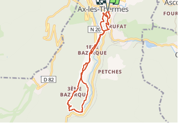
Trail Walking of 8.8 km to be discovered at Occitania, Ariège, Ax-les-Thermes. This trail is proposed by c.chehere.
Photos


Positioning
Country:
France
Region :
Occitania
Department/Province :
Ariège
Municipality :
Ax-les-Thermes
Location:
Unknown
Start:(Dec)
Start:(UTM)
405004 ; 4730256 (31T) N.
Comments