


harcourt-bec-helloin

thle
User
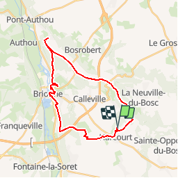

Length
26 km

Max alt
144 m

Uphill gradient
371 m
Km-Effort
31 km

Min alt
48 m

Downhill gradient
370 m
Boucle
Yes
Creation date :
2015-05-16 00:00:00.0
Updated on :
2015-05-16 00:00:00.0
6m
Difficulty : Unknown

FREE GPS app for hiking
 SityTrail
IGN / Geographical institutes
SityTrail Plus
The world is yours!
About
Trail Equestrian of 26 km to be discovered at Normandy, Eure, Harcourt. This trail is proposed by thle.
Positioning
Country:
France
Region :
Normandy
Department/Province :
Eure
Municipality :
Harcourt
Location:
Unknown
Start:(Dec)
Start:(UTM)
338742 ; 5449039 (31U) N.
Comments