


Resteigne Patrick..

r.genette
User
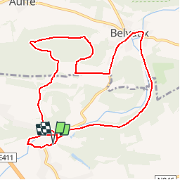

Length
10.2 km

Max alt
288 m

Uphill gradient
184 m
Km-Effort
12.6 km

Min alt
170 m

Downhill gradient
188 m
Boucle
Yes
Creation date :
2015-05-16 00:00:00.0
Updated on :
2015-05-16 00:00:00.0
2h44
Difficulty : Medium

FREE GPS app for hiking
 SityTrail
IGN / Geographical institutes
SityTrail Plus
The world is yours!
About
Trail Walking of 10.2 km to be discovered at Wallonia, Luxembourg, Tellin. This trail is proposed by r.genette.
Description
Du château vers Belvaux et retour par le bois de Niau
Points of interest


Positioning
Country:
Belgium
Region :
Wallonia
Department/Province :
Luxembourg
Municipality :
Tellin
Location:
Resteigne
Start:(Dec)
Start:(UTM)
655559 ; 5550840 (31U) N.
Comments