


R1T-53S-Lardy

Jack-94
User
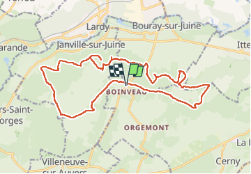

Length
21 km

Max alt
153 m

Uphill gradient
318 m
Km-Effort
25 km

Min alt
76 m

Downhill gradient
318 m
Boucle
Yes
Creation date :
2024-10-05 07:01:39.183
Updated on :
2024-10-05 19:59:24.039
7h33
Difficulty : Very difficult

FREE GPS app for hiking
 SityTrail
IGN / Geographical institutes
SityTrail Plus
The world is yours!
About
Trail Walking of 21 km to be discovered at Ile-de-France, Essonne, Cerny. This trail is proposed by Jack-94.

Positioning
Country:
France
Region :
Ile-de-France
Department/Province :
Essonne
Municipality :
Cerny
Location:
Unknown
Start:(Dec)
Start:(UTM)
446796 ; 5372219 (31U) N.
Comments