


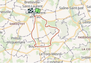
St LAURENT en CAUX

juanluco76
User

Length
10.6 km

Max alt
155 m

Uphill gradient
134 m
Km-Effort
12.4 km

Min alt
102 m

Downhill gradient
134 m
Boucle
Yes
Creation date :
2024-10-05 16:28:41.712
Updated on :
2024-10-05 16:32:28.098
2h48
Difficulty : Difficult

FREE GPS app for hiking
 SityTrail
IGN / Geographical institutes
SityTrail Plus
The world is yours!
About
Trail Walking of 10.6 km to be discovered at Normandy, Seine-Maritime, Saint-Laurent-en-Caux. This trail is proposed by juanluco76.
Positioning
Country:
France
Region :
Normandy
Department/Province :
Seine-Maritime
Municipality :
Saint-Laurent-en-Caux
Location:
Unknown
Start:(Dec)
Start:(UTM)
347138 ; 5513113 (31U) N.
Comments