


allondrelle 10.10.2024

jcb48
User
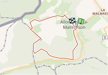

Length
7.2 km

Max alt
370 m

Uphill gradient
206 m
Km-Effort
10 km

Min alt
278 m

Downhill gradient
205 m
Boucle
Yes
Creation date :
2024-10-06 08:07:06.469
Updated on :
2024-10-06 08:07:57.197
2h16
Difficulty : Easy

FREE GPS app for hiking
 SityTrail
IGN / Geographical institutes
SityTrail Plus
The world is yours!
About
Trail On foot of 7.2 km to be discovered at Grand Est, Meurthe-et-Moselle, Allondrelle-la-Malmaison. This trail is proposed by jcb48.
Description
marche
Positioning
Country:
France
Region :
Grand Est
Department/Province :
Meurthe-et-Moselle
Municipality :
Allondrelle-la-Malmaison
Location:
Unknown
Start:(Dec)
Start:(UTM)
685702 ; 5487243 (31U) N.
Comments