


rando anc

Tommy Eric
User
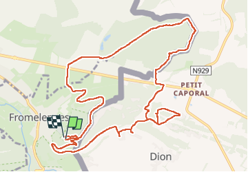

Length
12.9 km

Max alt
244 m

Uphill gradient
306 m
Km-Effort
17 km

Min alt
113 m

Downhill gradient
301 m
Boucle
Yes
Creation date :
2024-10-07 09:31:43.563
Updated on :
2024-10-07 14:06:41.484
4h34
Difficulty : Difficult

FREE GPS app for hiking
 SityTrail
IGN / Geographical institutes
SityTrail Plus
The world is yours!
About
Trail Walking of 12.9 km to be discovered at Grand Est, Ardennes, Fromelennes. This trail is proposed by Tommy Eric.
Description
rando
Positioning
Country:
France
Region :
Grand Est
Department/Province :
Ardennes
Municipality :
Fromelennes
Location:
Unknown
Start:(Dec)
Start:(UTM)
633292 ; 5553714 (31U) N.
Comments