


la reid

jbo1
User
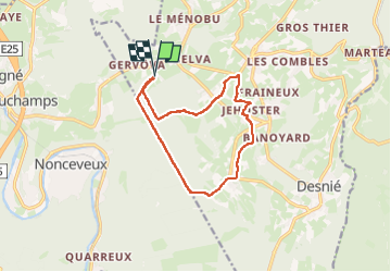

Length
11.1 km

Max alt
420 m

Uphill gradient
223 m
Km-Effort
14 km

Min alt
298 m

Downhill gradient
223 m
Boucle
Yes
Creation date :
2024-10-07 13:26:57.577
Updated on :
2024-10-07 15:38:40.912
2h04
Difficulty : Difficult

FREE GPS app for hiking
 SityTrail
IGN / Geographical institutes
SityTrail Plus
The world is yours!
About
Trail Walking of 11.1 km to be discovered at Wallonia, Liège, Theux. This trail is proposed by jbo1.
Photos


Positioning
Country:
Belgium
Region :
Wallonia
Department/Province :
Liège
Municipality :
Theux
Location:
La Reid
Start:(Dec)
Start:(UTM)
695723 ; 5596113 (31U) N.
Comments