


Cerisy memeche

memeche
User
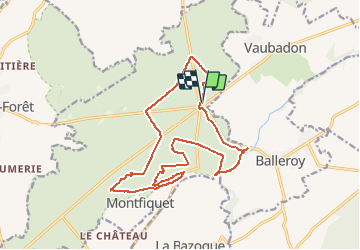

Length
16.9 km

Max alt
144 m

Uphill gradient
251 m
Km-Effort
20 km

Min alt
56 m

Downhill gradient
248 m
Boucle
Yes
Creation date :
2015-05-17 00:00:00.0
Updated on :
2015-05-17 00:00:00.0
2h15
Difficulty : Medium

FREE GPS app for hiking
 SityTrail
IGN / Geographical institutes
SityTrail Plus
The world is yours!
About
Trail Other activity of 16.9 km to be discovered at Normandy, Calvados, Montfiquet. This trail is proposed by memeche.
Positioning
Country:
France
Region :
Normandy
Department/Province :
Calvados
Municipality :
Montfiquet
Location:
Unknown
Start:(Dec)
Start:(UTM)
655627 ; 5451262 (30U) N.
Comments