


J4 Cilaos

PhilippeC54
User
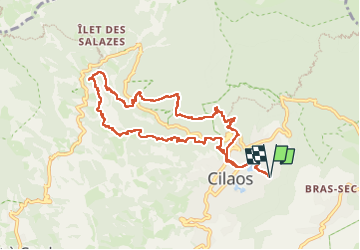

Length
14.3 km

Max alt
1379 m

Uphill gradient
821 m
Km-Effort
25 km

Min alt
904 m

Downhill gradient
821 m
Boucle
Yes
Creation date :
2024-10-09 04:40:52.495
Updated on :
2024-10-09 12:49:16.922
4h32
Difficulty : Difficult

FREE GPS app for hiking
 SityTrail
IGN / Geographical institutes
SityTrail Plus
The world is yours!
About
Trail Walking of 14.3 km to be discovered at Réunion, Unknown, Cilaos. This trail is proposed by PhilippeC54.
Positioning
Country:
France
Region :
Réunion
Department/Province :
Unknown
Municipality :
Cilaos
Location:
Unknown
Start:(Dec)
Start:(UTM)
342109 ; 7662061 (40K) S.
Comments