


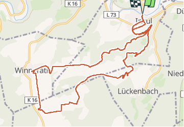
Insul

suntajl
User

Length
12.6 km

Max alt
535 m

Uphill gradient
332 m
Km-Effort
17.1 km

Min alt
219 m

Downhill gradient
332 m
Boucle
Yes
Creation date :
2024-09-29 07:50:44.534
Updated on :
2024-11-23 09:46:20.46
3h52
Difficulty : Medium

FREE GPS app for hiking
 SityTrail
IGN / Geographical institutes
SityTrail Plus
The world is yours!
About
Trail Walking of 12.6 km to be discovered at Rhineland-Palatinate, Landkreis Ahrweiler, Insul. This trail is proposed by suntajl.
Positioning
Country:
Germany
Region :
Rhineland-Palatinate
Department/Province :
Landkreis Ahrweiler
Municipality :
Insul
Location:
Unknown
Start:(Dec)
Start:(UTM)
351972 ; 5589812 (32U) N.
Comments