


Loutteville (Champcueil ) oct.24

mouchette94
User
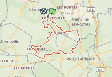

Length
17.6 km

Max alt
153 m

Uphill gradient
279 m
Km-Effort
21 km

Min alt
81 m

Downhill gradient
279 m
Boucle
Yes
Creation date :
2024-10-09 15:20:51.425
Updated on :
2024-10-09 15:22:58.673
4h50
Difficulty : Medium

FREE GPS app for hiking
 SityTrail
IGN / Geographical institutes
SityTrail Plus
The world is yours!
About
Trail On foot of 17.6 km to be discovered at Ile-de-France, Essonne, Champcueil. This trail is proposed by mouchette94.
Positioning
Country:
France
Region :
Ile-de-France
Department/Province :
Essonne
Municipality :
Champcueil
Location:
Unknown
Start:(Dec)
Start:(UTM)
460039 ; 5372930 (31U) N.
Comments