


Warnant

thomarche
User

Length
4.1 km

Max alt
235 m

Uphill gradient
87 m
Km-Effort
5.4 km

Min alt
151 m

Downhill gradient
118 m
Boucle
No
Creation date :
2024-10-10 12:11:18.0
Updated on :
2024-10-10 13:49:33.263
1h37
Difficulty : Easy

FREE GPS app for hiking
 SityTrail
IGN / Geographical institutes
SityTrail Plus
The world is yours!
About
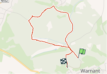
Trail Walking of 4.1 km to be discovered at Wallonia, Namur, Anhée. This trail is proposed by thomarche.
Description
Chouette petite boucle dans les bois entre Warnant et Bioul.
Positioning
Country:
Belgium
Region :
Wallonia
Department/Province :
Namur
Municipality :
Anhée
Location:
Unknown
Start:(Dec)
Start:(UTM)
630441 ; 5576503 (31U) N.
Comments