


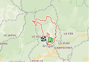
LL34-ArrigasSt Peyre-Tempêtes

alainandrejoly
User

Length
15.4 km

Max alt
1257 m

Uphill gradient
784 m
Km-Effort
26 km

Min alt
508 m

Downhill gradient
780 m
Boucle
Yes
Creation date :
2015-11-23 00:00:00.0
Updated on :
2015-11-23 00:00:00.0
5h23
Difficulty : Medium

FREE GPS app for hiking
 SityTrail
IGN / Geographical institutes
SityTrail Plus
The world is yours!
About
Trail Walking of 15.4 km to be discovered at Occitania, Gard, Arrigas. This trail is proposed by alainandrejoly.
Description
17/05/2015
Positioning
Country:
France
Region :
Occitania
Department/Province :
Gard
Municipality :
Arrigas
Location:
Unknown
Start:(Dec)
Start:(UTM)
538487 ; 4870832 (31T) N.
Comments