


Test UTDF

cps46
User
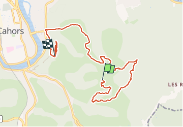

Length
11 km

Max alt
281 m

Uphill gradient
555 m
Km-Effort
18.4 km

Min alt
126 m

Downhill gradient
554 m
Boucle
No
Creation date :
2024-10-12 07:55:54.0
Updated on :
2024-10-12 12:08:57.604

FREE GPS app for hiking
 SityTrail
IGN / Geographical institutes
SityTrail Plus
The world is yours!
About
Trail of 11 km to be discovered at Occitania, Lot, Cahors. This trail is proposed by cps46.

Positioning
Country:
France
Region :
Occitania
Department/Province :
Lot
Municipality :
Cahors
Location:
Unknown
Start:(Dec)
Start:(UTM)
378053 ; 4921612 (31T) N.
Comments