


Sob tulle aubazine mardil

Glurps
User
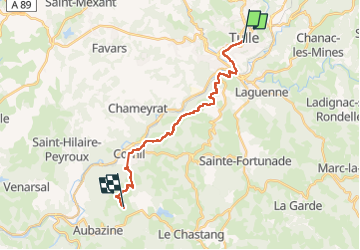

Length
18.7 km

Max alt
485 m

Uphill gradient
586 m
Km-Effort
26 km

Min alt
202 m

Downhill gradient
328 m
Boucle
No
Creation date :
2024-10-12 07:42:38.0
Updated on :
2024-10-12 17:13:44.597

FREE GPS app for hiking
 SityTrail
IGN / Geographical institutes
SityTrail Plus
The world is yours!
About
Trail of 18.7 km to be discovered at New Aquitaine, Corrèze, Tulle. This trail is proposed by Glurps.
Photos


Positioning
Country:
France
Region :
New Aquitaine
Department/Province :
Corrèze
Municipality :
Tulle
Location:
Unknown
Start:(Dec)
Start:(UTM)
403506 ; 5013185 (31T) N.
Comments