


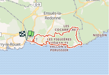
EnsuesLaRedonneDépartCarryObservatoire

ysst
User

Length
17.1 km

Max alt
214 m

Uphill gradient
549 m
Km-Effort
24 km

Min alt
2 m

Downhill gradient
549 m
Boucle
Yes
Creation date :
2024-10-13 16:41:51.702
Updated on :
2024-10-14 18:42:18.114
5h32
Difficulty : Very difficult

FREE GPS app for hiking
 SityTrail
IGN / Geographical institutes
SityTrail Plus
The world is yours!
About
Trail Walking of 17.1 km to be discovered at Provence-Alpes-Côte d'Azur, Bouches-du-Rhône, Carry-le-Rouet. This trail is proposed by ysst.
Description
Départ parking de l'Observatoire, Carry-le-Rouet
Positioning
Country:
France
Region :
Provence-Alpes-Côte d'Azur
Department/Province :
Bouches-du-Rhône
Municipality :
Carry-le-Rouet
Location:
Unknown
Start:(Dec)
Start:(UTM)
676277 ; 4800296 (31T) N.
Comments